LiDAR vs. Reality: Understanding Accuracy in 3D Scanning
At the heart of every LiDAR scan is a simple principle: light pulses in, distances out.
A LiDAR sensor emits rapid bursts of laser light that bounce off surfaces and return to the sensor. By measuring the time it takes for each pulse to complete that journey, the system calculates exact distances and maps the geometry of a space point by point.
Multiply that process millions of times per second, and you get a high-density point cloud: a digital snapshot of the real world, accurate down to the millimeter under the right conditions.
Understanding that measurement process is the key to understanding LiDAR’s accuracy.
The type of sensor, the environment, and how the data is processed all influence how close your digital model gets to reality, and whether it’s trustworthy enough for documentation, design, or decision-making. That’s what this guide will explore.
Understanding LiDAR accuracy: What the numbers mean
When people talk about LiDAR being “accurate,” they’re usually referring to how closely a 3D scan reflects the real-world dimensions of a space. But accuracy in LiDAR isn’t a one-size-fits-all metric. Rather, it depends on how the measurements are taken and how they're used.
There are two core types of accuracy to understand:
Absolute accuracy refers to how closely the scan aligns with the true global position of objects in space. It's critical when your model needs to match survey control points or integrate into BIM or CAD environments.
Relative accuracy describes how consistent the measurements are within a scan and how precisely objects relate to each other, even if the entire model is slightly offset from a global reference.
The accuracy a project needs depends on the specific workflow it is being used for. For applications like as-built documentation or facility walkthroughs, high relative accuracy enables teams to measure, inspect, and collaborate with confidence. Absolute accuracy becomes more critical for tasks like design validation, clash detection, or survey-grade documentation.
Even within single projects, different precisions may be suitable. A construction team documenting weekly progress and a construction team validating prefab tolerances have almost nothing in common in terms of required precision, even though both may sit inside the same project.
You can think about LiDAR accuracy in these real-world terms:
2mm accuracy lets you identify structural misalignments, detect minor design conflicts, or validate tight tolerances in prefabrication.
20mm accuracy is suitable for architectural planning, MEP layout coordination, and documenting large-scale spaces where minor variances won't disrupt workflows.
100mm+ accuracy is best reserved for visual-first applications like virtual tours or quick spatial overviews, where measurement precision isn't mission-critical.
In other words: the tighter the tolerances your project demands, the more carefully you need to consider the accuracy profile of your LiDAR system.
The table below breaks down typical tolerance requirements by vertical and workflow:
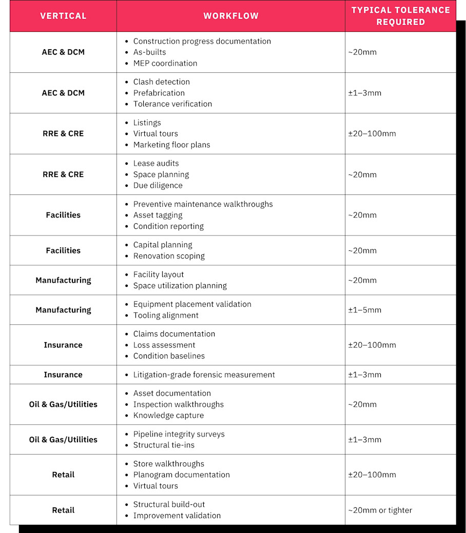
Across all verticals, documentation, planning, and coordination workflows generally tolerate variances in the 20mm range. This is the range that Matterport’s Pro3 delivers at typical working distances, with a dimensional accuracy typically within 1% to 2% of reality.
Precision requirements only tighten to single-digit millimeters once a workflow crosses into structural validation, tolerance-critical fabrication, or forensic-grade measurement. That work calls for a dedicated survey-grade scanner regardless of which industry it's happening in.
8 factors impacting LiDAR accuracy
Even with a high-spec scanner, LiDAR accuracy isn’t guaranteed out of the box. A range of environmental, technical, and workflow factors can influence how closely your scan matches real-world conditions.
Understanding these variables is key to producing reliable, high-precision models that teams can trust for measurement, validation, and documentation.
1. Sensor hardware and calibration
Over time, sensors can experience calibration drift, a gradual misalignment that introduces errors into scan data. Regular calibration is essential for maintaining consistency, especially on high-frequency or multi-location projects.
Many professional-grade scanners include automated calibration routines or precision components that reduce drift. Lower-cost or consumer-grade devices may lack these features, which can impact reliability. When accuracy is a requirement, sensor quality and calibration practices matter.
2. Environmental conditions
Because LiDAR relies on reflected light, scanning conditions have a direct impact on accuracy. Bright sunlight, shiny floors, fog, dust, or rain can all distort the return signal, leading to noise or gaps in the point cloud.
Teams can mitigate these effects by scanning in consistent lighting, avoiding reflective surfaces where possible, and using alignment aids for complex layouts. Some modern cameras, like Matterport’s Pro3, are specifically designed to operate in variable lighting, including outdoors in direct sunlight, helping reduce environmental constraints on data quality.
3. Scan range and angular resolution
The distance between the scanner and a surface has a measurable effect on accuracy. As the range increases, so does the margin of error. For example, a scanner rated at ±20mm at 10 meters may deliver larger variances beyond that range.
Angular resolution—the density of points captured across a horizontal or vertical arc—also plays a role. Higher resolution enables finer detail capture, while lower resolution may smooth over small objects or tight geometries. For projects involving large rooms, tall ceilings, or fine features, both range and resolution need to be considered together.
4. GNSS and IMU integration
In mobile and aerial LiDAR systems, accuracy depends not only on how the environment is scanned, but also on how the scanner’s position is tracked. GNSS (Global Navigation Satellite Systems) and IMUs (Inertial Measurement Units) help map the scanner’s path and orientation, allowing software to correctly stitch together complex data sets.
When these systems are misaligned or malfunctioning, even high-quality scan data can become distorted or misregistered. GNSS and IMU integration are particularly important for large-scale mapping, infrastructure surveys, or any scanning conducted while in motion.
5. Data processing and post-processing
Raw point clouds require significant processing to become usable 3D models. This includes noise filtering, scan alignment, surface reconstruction, and meshing. Without these steps, the scan may appear complete but contain structural inaccuracies.
Cloud-based platforms can simplify this process by applying automated algorithms to clean and align data. For example, Matterport’s cloud processing pipeline uses AI to refine scans and apply consistent labeling. Whether handled in-house or through a capture platform, post-processing is where much of a scan’s accuracy is either preserved or lost.
6. Mechanical stability during capture
Movement is another key source of error, especially for handheld or mobile scanning systems. Vibrations, shifting weight, or rapid motion during capture can introduce distortions into the scan, even if the sensor itself is functioning correctly.
Best practices include using tripods, minimizing foot traffic during scans, and slowing down motion in sensitive areas. Stabilization protects image quality and, more importantly, preserves the geometric integrity of the scan data.
7. Resolution vs. accuracy
It’s easy to confuse visual fidelity with geometric accuracy. High-resolution scans contain more points, which may create sharper visuals. But that doesn’t guarantee those points are correctly placed.
Accuracy is about how close the data points are to real-world measurements. Resolution is about how many points are captured. It’s possible to produce a beautiful 3D model that’s dimensionally unreliable, and vice versa. For measurement-critical tasks, users should prioritize systems and workflows that support both accurate geometry and reliable alignment.
8. Cost vs. time trade-offs
In scanning workflows, higher accuracy usually comes at a cost. Achieving ±2mm precision usually comes with slower scans, more setup, and additional post-processing. That level of precision is essential for tasks like prefabrication or structural validation, but overkill for others.
Higher-precision LiDAR workflows can also create operational bottlenecks. Specialized hardware is often shared across teams, and the resulting point cloud data typically requires dedicated software licenses and experienced operators for technology typically used by surveying and GIS professionals.
For many applications, the ±10–20mm accuracy of Matterport’s Pro3 is sufficient to guide decisions, document spaces, or support remote collaboration. Understanding where that threshold lies for your team helps balance project scope, equipment investment, and field time.
Smartphone LiDAR vs. professional scanner: Which hardware is best for the job?
LiDAR systems vary widely in precision depending on their design, calibration, and use case. Most professional-grade terrestrial scanners offer millimeter-level accuracy, while handheld or mobile LiDAR systems may range from a few millimeters to several centimeters.
LiDAR Scanner Type | Typical Accuracy |
Survey-grade tripod scanners | ±1–3mm |
Pro-grade hybrid scanners (e.g. Matterport Pro3) | ±20mm at 10 meters |
Smartphone LiDAR (e.g. iPhone) | ±100–200mm |
As LiDAR has made its way into smartphones and tablets, it's become more accessible for casual use. But greater accuracy isn't automatically the better choice; it's a trade-off, not a straight upgrade path.
Alongside accuracy, there are a number of other considerations you should make when deciding whether you can use smartphone LiDAR. Higher precision generally creates more value: tighter measurements, more reliable handoffs to downstream tools, more confidence in the model. But it also comes with slower capture, more setup time, larger files, and usually a higher cost per scan.
For measurement-critical work, that trade is worth making every time. If you're capturing spaces for design validation, coordination, or handoff to downstream tools like BIM or CAD, skimping on accuracy can produce errors that cost far more than the hardware would have.
For other work, ask what a given workflow is willing to pay for in time, cost, and complexity to get more precision than it needs. Around 95% of AEC workflows, along with use cases like virtual tours and property marketing, are well served by ±20mm accuracy. Beyond that threshold, additional precision often just costs more to produce and takes longer to deliver.
Let's break down where phone-based LiDAR earns its keep, where it doesn't, and where the ROI math shifts in favor of paying for more precision.
When phone-based LiDAR is sufficient
Smartphone LiDAR (like the ones built into recent iPhones and iPads) can be surprisingly effective for lightweight scanning tasks. While it lacks the precision of dedicated hardware, it’s often accurate within a few centimeters, making it suitable for basic spatial documentation where fine tolerances aren’t critical.
Use cases where smartphone LiDAR works well include:
Informal walkthroughs for clients, stakeholders, or team members who need a general sense of the space
Pre-visit site assessments to understand the layout or access before committing to a full scan
Quick measurements for furniture placement, space planning, or estimating materials in residential settings
Visual documentation of small or simple spaces where high fidelity isn’t required
To get the best results, consistency matters. Move slowly and steadily while scanning, maintain a clear line of sight to surfaces, and avoid abrupt changes in direction. Because smartphone sensors have a shorter effective range, staying within a few meters of the target surface will yield more reliable geometry.
Matterport’s mobile app offers a practical entry point for teams looking to experiment with 3D capture using the tools they already have. While the output isn’t suited for tasks like clash detection or detailed as-builts, it’s often more than enough for everyday documentation, sharing, and collaboration.
When specialized LiDAR scanners are required
When measurements need to hold up across trades, across tools, or across time, smartphone-grade LiDAR isn't enough, and the cost of a bad measurement outweighs the cost of better hardware.
Dedicated scanners are purpose-built to deliver consistent results at scale. They incorporate higher-grade components, precise calibration systems, and optimized optics that allow them to maintain accuracy across longer distances and larger areas. For example, the Matterport Pro3 delivers ±20mm accuracy at a 10-meter range and captures with speed and consistency that mobile devices can't replicate.
The power is demonstrated in the quality of the final outputs:
A smartphone scan of a large room may appear visually complete but contain subtle warping or depth distortion, especially near the edges.
A professional scan of the same space preserves true geometry, supports accurate measurement, and offers higher confidence when overlaid with CAD or BIM models.
Specialized hardware also excels in tough environments such as outdoor spaces, dimly lit areas, or industrial sites where mobile sensors may struggle with reflections, depth range, or noise. And because these devices are designed for repeatable use, they deliver more reliable results across multiple jobs or operators, reducing the risk of costly rework.
If you're scanning for documentation, planning, coordination, or compliance, a professional-grade LiDAR system offers the level of detail and dependability those workflows demand.
Some cameras, like Matterport’s Pro3, are specifically designed to be accessible to use, but architects, engineers, and operations leaders don't always have the time or site expertise to run hardware themselves. Matterport’s Capture Services allow them to outsource scanning to trained technicians who deliver professional-grade results without requiring an in-house scanning team or hardware investment.
Contextualizing the built world within LiDAR and digital twins
LiDAR accuracy isn't always a spec to maximize. It's a variable to match against the job in front of you. A ±2mm scanner and a ±100mm smartphone are both "accurate" in the sense that matters for their intended use—the mistake is applying either one to a workflow it wasn't built for.
That's where the Matterport Pro3 occupies useful territory. At ±20mm accuracy at a 10-meter range, it lands in the middle of the spectrum: tighter than smartphone LiDAR by an order of magnitude, and far easier to deploy than survey-grade equipment. There's no tripod setup, no specialized operator training, and no multi-thousand-dollar hardware investment.
Its feature combination is precise enough to satisfy the accuracy requirements of most documentation, planning, and coordination workflows, which is the majority of what teams in real estate, facilities, and design actually need day to day. The Pro3 is also built to handle bright outdoor conditions, scanning exteriors and sunlit interiors without the depth distortion that trips up many LiDAR systems.
For most property documentation workflows, that’s a sweet spot:
Reliable geometry without bulky hardware
One scanner for both indoor and outdoor capture
Quick, repeatable results across multiple sites
Once a space is captured, Matterport's platform adds another layer of verification: Automated Measurement tools that let anyone pull dimensions and confirm 90-degree angles directly from the model. For workflows like space planning, lease audits, or pre-renovation scoping, that's often enough to confirm a dimension or catch a discrepancy without dispatching someone to re-measure in person.
It’s important to note, though, where this level of accuracy fits. The Pro3 isn't designed for measurement-critical construction workflows like clash detection, prefabrication layout, or tolerance verification—survey-grade scanners still lead in those contexts.
Instead, Matterport’s strength lies in contextual accuracy and workflow simplicity. Its cloud platform processes LiDAR data into:
Dimensioned floor plans for planning and documentation
Point cloud interoperability, with Matterport-generated point clouds and a Point Cloud Import tool to combine engineering-grade accuracy with digital twins
BIM and CAD exports for design, coordination, and downstream AEC workflows
Immersive virtual tours that embed real-world scale into every view
The throughline across this guide is simple: match your accuracy requirement to your workflow, not the other way around. The Pro3’s combination of reliable accuracy, broad capture range, and easy file outputs makes it a practical solution for teams that need to bring the built world into focus, without getting buried in technical complexity.
Get in touch with our team