


 Sign In
Turn a Leica Point Cloud Into a Digital Twin Your Whole Team Can Open
Chances are there's a drive somewhere in your office with a Leica point cloud on it. There’s also a good chance the last person to open that file was the person who registered it.
Too often, survey-grade scan data sits in a format most of your team can't open. When a superintendent needs a clearance dimension, an architect needs to point at an RFI location, or an owner's rep needs to see the space, they're limited by their ability to interpret a raw E57.
In this guide, we’ll teach you how to turn a Leica point cloud into a digital twin, so your whole team can open, navigate, measure, and mark up a space in a browser.
The problem with point-cloud-only deliverables
A raw Leica point cloud is a specialist deliverable. Opening the file takes specialist software, a workstation with the hardware to handle it, and someone trained to interpret what they're looking at. That might be the person who registered the scan, or maybe a VDC or BIM lead. Either way, the file's usefulness is capped by the availability of one or two people. When those specialists are loaded, everything downstream queues behind them:
A superintendent needs a single clearance dimension and waits a day for the VDC lead to open the file. The install decision stalls.
An architect describes an RFI location in a paragraph of text because they can't point at it in the scan. The recipient guesses.
An owner's rep asks for the model and gets a flat screenshot instead. Context disappears.
A fixture or equipment question comes up, nobody can check the scan, and someone drives back to site. A day is gone.
A subcontractor bids off drawings that no longer match field conditions. The gap surfaces as a change order.
Even with accurate survey data and a skilled team, bottlenecks pile up based simply on who's free to access and read the point cloud.
A digital twin acts as an access layer that sits on top of the survey data, so anyone with a link can open, walk, and interpret the 3D space without a license or a specialist.
The registered Leica point cloud remains the source of accuracy for the model, while the digital twin sits above it as the format the rest of the team can actually apply to their workflows, with no specialist software and no E57 expertise.
Turning your Leica point cloud into a digital twin won’t change the survey data or the original registered file. Those stay exactly as they are. Instead, it adds a new format, so the downstream queue behind your specialists disappears.
Despite employing its own modelers, even global architecture and engineering firm Arup found rapidly allocating resources to new projects a challenge. At the busy firm, modelers haven’t always had the capacity to deliver base models at speed, holding up engineers and collaborators from progressing projects.
After investing in Matterport along with Leica BLK360 cameras, Arup’s Regional Reality Capture Leader Michael Alder is finally able to fulfill the needs of teams the way he wants to: "It's just a button press away." Arup now delivers base models as coordinated, information-rich digital twins across their offices, so the queue for the baseline isn’t held up by high-detail modeling workflows.
How to turn a Leica point cloud into a digital twin in 6 steps
From registering your scans through sharing the finished model with each audience, this workflow turns a Leica scan from raw point cloud data into a browser-based digital twin anyone on the project can open.
1. Register Leica scans in ReCap
This step is almost certainly already part of your workflow. Scan registration should be done by whoever runs your survey data today, likely a surveyor, scanning technician, or VDC lead.
They won’t need to move the file or learn a new tool for it. Register scans in Leica Cyclone or Autodesk ReCap Pro, exactly as you would for any design or coordination deliverable. Matterport does not register scans, so don't look for that step inside Matterport: it belongs upstream, in your survey software.
A scanner like the Leica BLK360 captures a building from many positions, each with its own local coordinate origin. Registration stitches those positions into a single, unified point cloud tied to the project's coordinate reference, so every point sits where it actually belongs in the building.
Before moving on, confirm that the scans align cleanly to each other. Registration errors are easiest to fix at this stage. If you find them later, every piece of downstream work will already have carried them forward.
2. QA and clean the point cloud
Before you export anything, run the point cloud through a routine quality pass. This will improve the quality of the point cloud so the digital twin it produces is clean from the start.
Work through the following:
Remove noise and stray artifacts like floating points or reflections of passersby, so the twin isn't cluttered with points that don't represent the building.
Crop out areas that don't belong in the deliverable, like neighboring structures or overscanned exterior, to reduce the file size and keep the digital twin focused.
Merge scans into a single clean dataset, so the digital twin comes in as a coherent whole rather than fragments.
Validate coverage and density to confirm there are no gaps or thin spots in key areas, and that point density is high enough for the digital twin's intended use.
Confirm the level of detail meets the project requirements before you export. A coverage or resolution gap is far cheaper to fix now than after the file leaves your survey tools.
Do this pass thoroughly, because the finished digital twin will inherit the quality of the registered scan directly. Matterport reads the file you give it and can’t fix or improve it.
3. Export the point cloud as E57
E57 is a vendor-neutral format defined by the ASTM E2807 standard that nearly every 3D design tool on the market reads, and it travels consistently between platforms. Matterport accepts the E57 format directly, so there won’t need to be any proprietary conversion step.

Make sure to keep a copy of the original registered file untouched in your archive. The E57 export is a portable copy meant to travel, but you might want to return to the original point cloud deliverable in the future.
4. Import the E57 into Matterport
Matterport’s Point Cloud Import brings an existing E57 file directly into a Matterport account, automatically generating a navigable 3D digital twin. This is the step where a specialist file becomes something anyone can access.
Once imported, the model behaves like any other Matterport digital twin. Anyone you share it with can open it in a browser on any device, move through the space, take measurements, add contextual information, and pull spatial data. Rather than having to request and download information, all stakeholders have a working surface.
The new digital twin changes who can reach the data, not the data itself. Importing your E57 won’t reinterpret, re-register, or correct the point cloud, and the digital twin’s fidelity is only ever as good as the scan behind it. The accuracy belongs to the Leica device and the capture and registration work behind it. A Leica BLK360, for example, delivers sub-centimeter accuracy suited to architectural and construction as-builts. Matterport leaves that geometry untouched, so the survey-grade precision your crew paid for will survive all the way to the person opening a link. Nothing is degraded in translation.
5. Organize the digital twin so it's navigable
Once processing finishes, spend a few minutes making the digital twin easy to walk through:
Confirm floors and levels read correctly.
Set a sensible starting viewpoint near the main entrance or the area of interest.
Check that navigation flows the way someone physically walking the building would expect.
For large or multi-floor sites, the Merge Spaces feature combines sections into a single model. This also handles updates in the future: if a single area changes, you can simply rescan that portion of the space and add it to the existing model, rather than rebuilding the whole thing.
If a digital twin will be leaving your immediate project team, use Trim to remove any sensitive sections and Blur for details like faces, license plates, or documents so the shared model doesn't expose anything it shouldn't.
6. Share your site and control what each audience sees
Finally, share a link with your team so they can view and interact with the digital twin. You can control exactly what each group actually sees by customizing Views. An owner's rep, an external contractor, and a project supervisor don't need the same layers or annotations, so give them access to the relevant information and nothing extra. This keeps sensitive information out of the hands of people who aren’t cleared to see it, and ensures every viewer is focused on the slice that's relevant to their role instead of wading through annotations meant for another trade.
Enterprise teams can also apply role-based permissions, SSO, and private embedding behind authenticated access so a digital twin lives inside an intranet or project portal without opening it to anyone with the link.
If your digital twin will be used for orientation, training, or a handover walkthrough, add a Guided Tour so first-time viewers are led through the space in a sequence, instead of finding their own way.
Digital twin workflows your team can run without waiting
Once the twin is shared, your team’s daily pattern will shift from request and wait to open and check. A Matterport digital twin adds a number of capabilities that unfreeze coordination-heavy work. Questions about a dimension, a spec, or a clash that used to sit in someone's inbox until a specialist was free are now items any team member can resolve themselves, at the moment the question comes up. The workflows below remove the most common sources of friction.
Attach useful context to the space it describes
Documents that detail fixtures or MEP runs usually live in an email thread, shared drive, or spreadsheet. Whoever needs it has to know it exists, find the right message, and mentally map it back to a physical location.
A digital twin stores that context at the exact spot it refers to, where anyone with view access can find it. Use Tags to pin text, photos, video, and file Attachments like a spec sheet, a warranty, or a coordination note directly to a piece of equipment or a location.
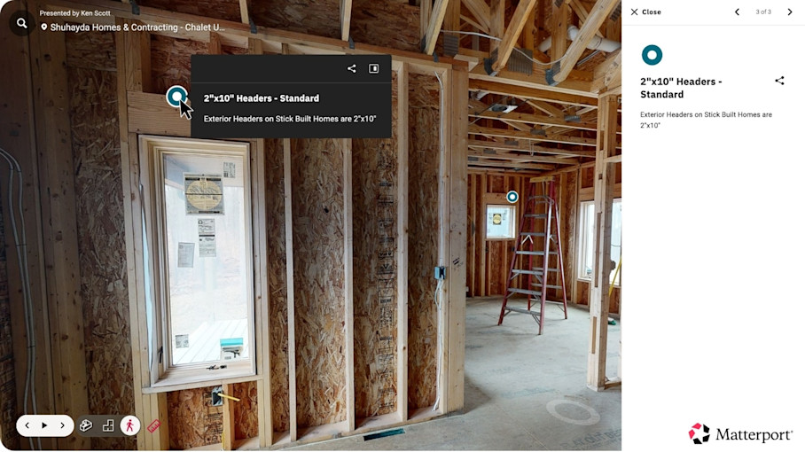
Teams can also collaborate in real-time inside the digital twin. Add Notes with mentions, file sharing, and task tracking, so a decision about a space stays attached to that space instead of scattering across inboxes. A Note thread on a congested ceiling zone, for instance, can resolve a clash question between the mechanical and electrical subs right where the conflict is, with everyone looking at the same geometry.
It’s a good idea to apply the same naming and tagging conventions you use for the source scans so the twin stays traceable back to the survey file.
Measure without waiting on the person who ran the scan
A routine dimensional question like “Will this unit fit through that doorway?” shouldn't stall a job, but it often does, because the only person who can pull the number is whoever has the point-cloud file open. Everyone else waits.
When the scan opens in a browser, that wait disappears. Anyone on the project can walk the space and take the measurement themselves, right where the question came up. Matterport’s in-model Measuring Tools will allow you to handle the majority of everyday queries like distances, wall lengths, object dimensions, and clearance checks around existing services.
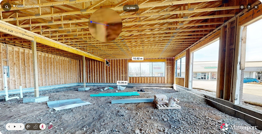
This is not a substitute for survey control. High-tolerance work like setting column lines, or anything else a contract requires at survey grade still belongs with the survey crew and original registered point cloud.
Most of the measurements your project team needs in a day aren't survey-control decisions. They're practical checks: does it fit, does it clear, roughly how much material. For these use cases, a digital twin is more than sufficient to act on. This frees the survey crew to spend their time on the decisions that genuinely require survey-grade detail, instead of fielding a steady stream of minor requests.
Pull spatial data automatically instead of deriving it by hand
Generating building information manually, calculating square footage, sketching layouts, and describing buildings is slow and error-prone across a whole space.
A digital twin provides a consistent baseline for that information. Matterport’s Property Intelligence generates room measurements, square footage, descriptions, and property layout data straight from the scan, replacing manual takeoff work. Schematic floor plans can also be generated, so the drawing your team would otherwise sketch by hand arrives ready to use.
Producing room-by-room areas for a full floor plate is a good example. The necessary information can be read off the digital twin, no need to wait for a point cloud specialist to produce the data, or for a team member to return to the site and walk the floor with a tape and a spreadsheet. Instead, a program validation or a lease exhibit that once took a day of manual measuring is in your hands instantly.
Verify a fast capture against your survey scan side by side
Teams often use fast reality capture scans for day-to-day questions. Survey-grade Leica scans are precise, but too slow and costly to redo every time something moves. Fast captures created using Matterport scanning solutions are relatively cheap and quick enough to repeat every week, making them a natural tool for documenting construction progress day-to-day.
A lower-accuracy scan is only worth trusting if you can see how it holds up against the survey-grade baseline. Usually you’d have to export the two scans into specialist software and align them by hand to confirm this.
With Matterport digital twins, teams can lean on a faster capture for routine progress verification, lining up a native Matterport capture against the Leica scan Side-by-Side (public beta), so they can be compared in one viewport on a shared coordinate system. This way, you can easily measure weekly progress captures against the survey-grade baseline, or review a space before-and-after renovations.
It’s worth noting that this comparison workflow depends on a coordinate-alignment step and is subject to a scan-point ceiling.
Coordinate issues where they physically occur
A vague written location for an RFI can quickly turn into several back-and-forth emails before anyone agrees on where the concern actually is. Orientation terms are ambiguous and the writer and reader often don’t share a vantage point, so people often have to re-confirm rather than assume.
Instead, drop an RFI pin at the exact point of concern in a digital twin. Matterport’s integrations allow issues to carry their precise spatial context into the design tools a team already runs. Open it in Autodesk Forma, Docs, Build, or Procore with that context intact, and the paragraph describing a location is replaced by the location itself. Issues, observations, and RFIs are created, assigned, and tracked against a shared spatial record rather than a written approximation.
These integrations coordinate a broad range of field workflows against the same model and teams using them resolve up to 75% of project issues independently without escalation to change orders.
Feed Revit, CAD, and BIM work
Getting a registered scan into design tools has traditionally meant manual file-shuttling: download, unzip, import, index, export, link, and then tracing over reference geometry by hand once it arrives. Both of those processes are slow, which often causes scans to sit idle.
A Matterport digital twin provides exportable registered asset data, which flows seamlessly into other platforms. True 3D exports cover several formats that feed a firm's other tools:
OBJ files: A textured 3D mesh for visualization, rendering, and dropping the space into 3D modeling or animation tools.
XYZ files: A lightweight, plain-text point cloud for when a team needs raw points without E57's structure.
E57 files: The vendor-neutral point cloud format we’ve covered above, this time containing any trimming, cropping, or merges that you have processed in Matterport.
CAD files: 2D/3D drawings for drawing-based workflows in drafting tools like AutoCAD.
BIM files: Ready-modeled Revit objects so teams can edit real building elements instead of tracing over a point cloud.
Matterport’s plug-in for Autodesk Revit pulls an already-registered asset straight into Revit as a linked RCP, and BIM Files arrive as ready-modeled Revit objects, rather than a point cloud to trace over, so teams can edit a space immediately.
Matterport’s modeled output meets a LOD 200 specification for structural and architectural elements, with MEP and Furniture available as add-ons. It's a reliable starting frame, not a finished high-LOD model. Detailed modeling should still happen in your BIM and CAD software, with the digital twin giving those tools a running start instead of a blank canvas.
HH Angus reported a 70% cost saving on BIM file creation using Matterport BIM Files.
Turn stranded Leica data into a shared resource
Matterport digital twins turn the survey point file your firm already owns into a browser-accessible resource for everyone downstream while keeping its original scan’s accuracy fully intact. Nothing about the capture changes. You simply stop letting the data sit behind one person's software.
The ecosystem stays open at every step. Keep your Leica scanner. Keep ReCap or Cyclone for registration. Add an access layer on top, and let the people who couldn't open the file yesterday walk the space today.
AEC teams already report:
Less rework, because coordination happens against a shared spatial record
Fewer site visits, when routine questions get answered in a browser
Faster coordination, with issues pinned to exact locations
Better stakeholder access to as-built documentation, from superintendents to owners' reps
If you own Leica scans that aren't earning their keep, the fix is a simple workflow, not another hardware purchase.
Get in touch with our team

