


 Connexion
3D Building Documentation Software vs Traditional Site Documentation
Key takeaways
Traditional site documentation scatters photos, spreadsheets, notes, and PDFs across disconnected files that lose context after crews leave the jobsite.
3D building documentation software keeps information pinned to a visual record of its exact location, so teams understand the full spatial context without scheduling a return visit.
Matterport digital twins capture and organize building documentation, make it available to all stakeholders at the point of need, and feed it into the other tools AEC teams run.
Traditional site documentation is usually a mix of photos, handwritten notes, and measurements taken by whoever was on-site that day. But later, when someone needs to verify a detail after the work is done, what if photos don't show the right angle or notes are hard to tie to a location? If the project manager who did the walkthrough has moved on, confirming one question can mean a return trip, if that part of the building is even accessible anymore.
3D building documentation software records the full spatial context of a jobsite, producing a record teams really can visit and re-measure months or years later.
This guide compares 3D building documentation software with traditional site documentation to help AEC teams see where each approach delivers the most value on their projects.
What is 3D building documentation software?
3D building documentation software captures, organizes, and manages spatial information about a building or site as a navigable 3D record of existing conditions. Instead of describing a space in scattered files, it produces a walkable digital twin: an accurate, immersive model of a real space that teams can revisit from any device.
Unlike manual 3D modeling, where a CAD or BIM modeler builds geometry from design intent and measurements, 3D documentation software documents reality as it was captured on site. It captures the built condition, not the design intent.
The two approaches work together. 3D outputs feed BIM and CAD tools directly, giving modelers an accurate as-built foundation instead of a blank canvas. You capture first, then model from the truth.
A number of disciplines use this software:
Architects document existing conditions before a renovation without a full measured survey.
Engineers check MEP rough-ins against the record instead of reopening walls.
Construction teams track progress and resolve issues from a shared model.
Designers walk clients through a space to approve concepts remotely.
Facilities managers keep a living reference for maintenance and space planning.
3D building documentation software consolidates the record into a single resource for construction planning, progress monitoring, and verification. It does this through the following core capabilities:
3D visualization of the captured space: Navigate the site as a walkable model rather than a set of flat images, so teams work from the actual space instead of an approximation.
Location-tied document and file management: Attach photos, files, and links to the exact spot they describe, keeping details connected to where they belong.
BIM and CAD compatibility: Export capture data into the design tools teams already run, so it drops straight into existing workflows.
Version history of captures over time: Keep dated captures that show how a space changed, catching issues before they compound into rework.
Reporting and measurement outputs: Generate dimensions, floor plans, and reports directly from the record, so measurements reflect what's actually there.
Workflow automation: Push issues, RFIs, and updates into connected project systems without manual re-entry.
Centralized project documentation management: Hold site, design, and project records in one place, so every stakeholder works from the same record.
With site, design, and project records centralized in 3D building documentation software, every stakeholder has a shared, current view of the same building.
3D building documentation software vs traditional site documentation
The clearest way to see the difference between 3D building documentation and traditional site documentation is to follow a single site condition through each method.
Here’s how the two approaches compare on key documentation tasks:
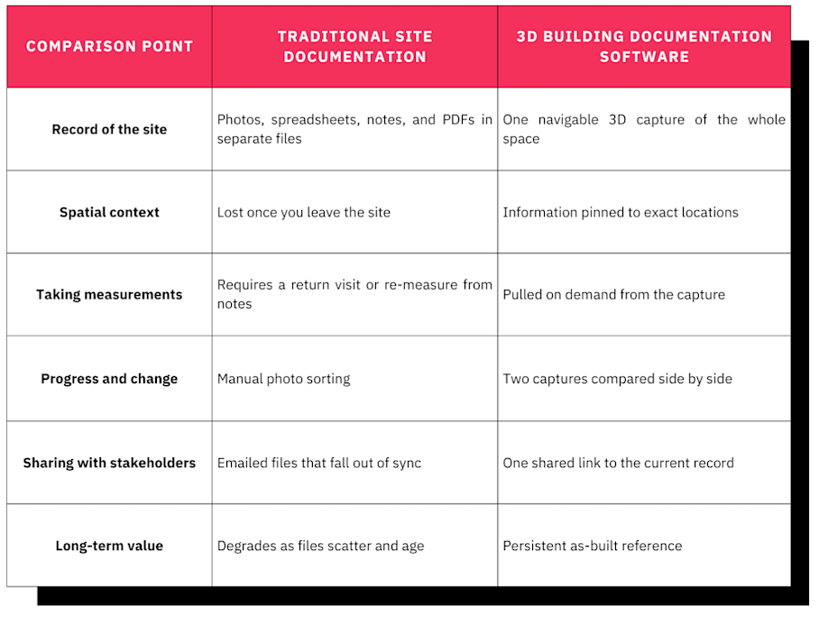
Now, let’s take a closer look at how they work.
Capturing the condition: photo folder vs. single capture
Traditional documentation creates four disconnected pieces: a folder of photos, a spreadsheet of measurements, handwritten observations, and a marked-up PDF. Each one is captured separately, and it's on you to reconcile them later: matching a photo to the right measurement, the right note, and the right point on the plan.
Alternatively, 3D documentation software uses reality capture to record the site and its condition in full. A camera or scanner takes overlapping images as it moves through the space, and the software stitches them into a dimensionally accurate 3D model. In one pass, you capture the visual condition, the spatial layout, and the measurements together, rather than as separate records.
Instead of several disconnected pieces to reconcile, a Matterport digital twin holds everything in context.
Keeping context: standalone files vs. location-pinned information
A photo of a rough-in might look identical to a dozen others taken the same week. Standalone files strip away spatial context, so your team is left guessing which floor or room the photo even came from.
In 3D building documentation software, you can Tag the specific location of a piece of work or issue and attach a photo, file, link, or observation. Teams pin information exactly where it was captured. From there, Notes let them comment and mention colleagues in a threaded conversation, right where the work happened.
Traditional documentation scatters information across files that lose their meaning, while 3D documentation ties information to the precise spot on site.
Getting measurements: return trips vs. on-demand dimensions
Confirming a single dimension the traditional way means trusting that the measurement you need is correctly recorded and intelligible in records, or driving back to the site if that’s not the case.
With 3D building documentation software, Automated Measurements generate room dimensions and floor plans are generated straight from the capture. For any spec that needs checking later, Measurement Mode lets teams verify rooms, walls, doorways, and furniture at any time, directly inside the model.
Gilbane’s team used in-model measurement to verify ADA desk and countertop heights without returning to the branch, part of a broader shift that saved the firm more than 1,000 hours in site travel.
Instead of sending someone back to the site, on-demand measurement pulls the number from the record you already have.
Sharing and reuse: version sprawl vs. one source of truth
With traditional documentation, a photo set might be emailed to three teams, who each mark it up, and within a week it’s already difficult to tell which copy is current. Any download spins off its own version, and every edit lives in a separate inbox, so reconciling them means tracking down who changed what, and when.
With a shareable digital twin, anyone with the link navigates the same record from the same link. A remote owner or engineer can both review real conditions without setting foot on site, and any measurements or comments are recorded in one source of truth. Everyone will always see the most up-to-date information.
Where to use 3D building documentation software across the building lifecycle
3D capture isn't the right tool for every task, and traditional photos and notes are proportionate when the job is small and self-contained. For example:
A single punch-list item with a clear photo
A quick supplier question answered by one snapshot
A small-footprint repair in a known location
A space already fully documented and unchanged
When a question is narrow, immediate, and unlikely to be revisited, more thorough documentation is overhead you don't need.
Now, let’s look at the cases where 3D building documentation software does outperform traditional methods.
Construction progress tracking
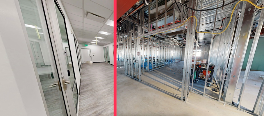
Capturing the same space at each construction milestone builds a dated timeline of the project. Each capture locks in what a stage looked like before the next one covered it (foundation, rough-in, close-up, finish) so the record shows what was behind the wall before it closed. That's exactly what teams need weeks later to verify progress claims, settle payment applications, and answer "what's back there?" without opening anything up.
Teams that already own survey-grade LiDAR scanners can build that timeline without adding a separate camera. Point Cloud Import brings existing E57 scan data into the same twin, so the equipment already on site feeds the record.
Every digital twin is aligned to real-world spatial dimensions, so comparing two captures of the same space Side-by-Side (public beta) in a synchronized view lets teams see exactly what changed between them and verify progress, rather than scrolling through photo folders trying to reconstruct the sequence.
Issues and RFIs can also be pinned to the precise location they concern and pushed directly into project management tools like Autodesk Forma and Procore, so a flagged problem carries its exact context instead of a vague description and a loose photo.
Renovations and before-and-after comparisons
A baseline capture of existing conditions gives a renovation team an accurate starting point. It informs scope, surfaces surprises early, and reduces change orders coming from not knowing what is behind a finish. Because the baseline records the space in full rather than as a handful of photos, the team can return to it for a measurement or a detail nobody thought to note at the time.
Comparing two 3D models, such as a baseline and post-project capture, documents the completed work. This before-and-after record shows exactly what changed, which supports sign-off and gives the owner clear proof of the work performed. That same record then carries forward as the new documented starting point for the next renovation, insurance claim, or space plan down the line.
As-built documentation and facilities handover
Project teams move on, but a digital twin remains as a living as-built record. Facility management teams revisit this documentation for maintenance, space planning, and asset management long after the drawings are filed away.
Equipment and assets can also be documented in place, so the operational details a facilities team needs stay attached to the physical thing they describe rather than scattered across binders and shared drives. A technician can locate a specific unit in the record and pull up the O&M manual, the warranty, or the service history without hunting through filing systems or tracking down whoever managed the original project.
Insurance, claims, and condition records
3D building documentation can serve as a baseline of conditions for insurance claims, underwriting, and disputes, giving an adjuster or attorney a file they can open years later to see exactly how a space looked on a given day. Because the record is time-stamped and measurable, it stands as strong evidence for claims processing and reduces the kinds of disputes that might surface when a photo was taken, or a dimension was estimated after the fact.
The shareable record also cuts the need for people to be physically present, letting remote reviewers assess conditions from the digital twin and produce estimating resources automatically. An adjuster, underwriter, and attorney can each work from the same record without scheduling around one another or the property itself.
Adding 3D building documentation software to your AEC workflow
Most teams weigh a few practical considerations before adopting 3D building documentation software.
Accuracy: For as-built documentation and BIM validation, a capture is only useful if its measurements can be trusted like a tape measure. Matterport’s Pro3 camera captures detailed spatial data with LiDAR and is rated at ±20 mm accuracy at 10 meters, tight enough for as-built documentation, measurement checks, and BIM and CAD validation.
Ease of capture: Documentation that slows down a site visit tends not to happen, so how quickly a team can capture a space determines whether it gets done consistently. Field teams scan a space for a Matterport digital twin in a single walk, with each sweep taking under 20 seconds, so capture fits inside an existing site visit rather than adding a separate trip. Anyone on the team can run it without a trained scan operator.
Hardware and training: Buying cameras and training staff is a real barrier to adoption, especially for teams that only need captures periodically. Matterport’s capture workflows are easy for anyone to execute. Additionally, Capture Services sends Matterport-trained technicians to scan a space and deliver a digital twin in as fast as 24 to 48 hours, so an organization can get professional captures without buying cameras or training internally.
Workflow: Capture data should only connect to the tools teams already design and document in, rather than becoming a separate silo to manage. Exports like BIM and CAD files, point clouds, and integrations connect captures to the most popular design and documentation tools.
Matterport’s 3D building documentation software doesn't replace a process that already works, but adds to it.
Set the cost of a capture against manual surveys, repeated walkthroughs, and the hours lost reconciling files, and the math favors capture on most projects. Teams report fewer return trips, less rework, and faster reviews once one record replaces the scattered set.
Optimisez vos flux de travail AEC/DCM avec Matterport


