

 Anmelden
5 Best 3D Scanning Tools for Facility Safety Inspections
Key takeaways
Choose your scanning method based on the inspection requirement. 360 cameras work well for fast visual documentation, mobile LiDAR suits small or contained spaces, and survey-grade scanners are appropriate when millimeter-level accuracy is critical.
Matterport Pro3 is the strongest all-around option for recurring facility safety inspections, creating a reusable spatial record that can support inspections, audits, collaboration, and follow-up work.
Use the Insta360 X5 when speed, portability, and cost matter more than dimensional accuracy. It is well suited to routine visual walkarounds and supplementary documentation.
Survey-grade tools such as the Leica BLK360 and FARO Focus are best reserved for precision-critical work like structural analysis, clearance verification, complex industrial environments, and forensic investigations, where the cost is worth it.
Facility safety inspectors often have to walk into the places most people avoid. Visiting elevated platforms, energized electrical rooms, confined tanks, and live process areas carries risk. Inspections captured using handwritten notes or flat photos often leave gaps that someone has to fill later, usually by going back.
3D scanning tools for facility safety inspections capture spaces in full dimensional detail, so teams can document hazards, revisit conditions, and inspect challenging environments without repeatedly sending people into them.
In this guide, we’ll cover capture methods and hardware options so you can match the right device to your inspection environment, the level of detail you need, and what your team does with the data afterward.
Here's how the 3D scanning tools compare at a glance:

Hardware data is accurate as of publishing, September 2026.
Important note: The tools on this list are organized by inspection type and workflow suitability, not ranked. Most EHS and facilities teams combine more than one, rather than relying on a single tool for every inspection.
Choosing the right 3D scanning method
Before comparing individual products, it helps to understand the capture approaches each is based on. Different capture methods suit different inspection environments and workflows based on how depth is captured, how far the sensor reaches, and what the output looks like when you're done. Read this framework to make it easier to weigh against your own program.
360 photo and photogrammetry capture
360 cameras use two or more fisheye lenses to shoot overlapping images, which are then stitched with photogrammetry into a single spherical view of the room. This method gives you fast and often inexpensive visual coverage of the facility. It also gives you the weakest dimensional reliability. You can document an entire floor in a fraction of the time a laser scanner needs, but depth isn't measured during the scan, so any dimension you pull from the picture will be an estimate rather than a true reading. For many routine tasks, it’s still a useful method.
360 photo and photogrammetry capture tools are best suited to inspections that are visual by nature, such as:
Daily or pre-shift walkarounds
Quick condition checks before a task starts
Fast incident snapshots when something needs recording right now
Mobile device LiDAR
LiDAR-equipped mobile devices carry a small time-of-flight sensor. It measures depth by timing pulses of light bounced off nearby surfaces, which leads to accurate measurements within a small space.
The range of these devices limits the use cases. Point it at a single wall or a piece of equipment and it will perform well, but try to capture a large open space by walking it and the model will drift, because errors accumulate as you move.
Mobile LiDAR devices are best suited to small and contained inspections, such as:
Single rooms and offices
Electrical closets and confined equipment areas
Spot documentation between formal, scheduled inspections
LiDAR-based digital twin platforms
These systems use a LiDAR camera which captures accurate depth data plus high-resolution panoramic imagery to create navigable digital twins that replicate the facility. You can then walk the 3D space from a browser, pull dimensions, and see photorealistic detail at every point.
The output is a real differentiator for EHS teams. Rather than a file that sits on a drive, you receive a reusable environment. Inspectors, contractors, insurers, and corporate safety leads can all revisit the same location without returning to site, and the record stays available to compare against the next audit cycle.
LiDAR-based digital twin platforms are best suited to recurring and shared inspections, such as:
Facility-wide safety audits that repeat on a schedule
Hazard documentation that needs annotation and follow-up
Pre-task planning and multi-site compliance programs
Survey-grade terrestrial laser scanners
Survey-grade terrestrial scanners are precision capture devices. They deliver millimeter-level tolerances, long range, and dense point cloud deliverables built for engineering-grade analysis. This hardware can produce numbers that hold up in a structural calculation or a code dispute.
It’s worth keeping in mind that these tools come at a cost: they’re typically expensive, heavy, and demand operator training. Each scan also has to be registered and processed afterward, which can add hours of desk work, and a single site can require dozens of setups to cover fully.
Survey-grade terrestrial laser scanners are best suited to inspections that justify that effort, such as:
Structural deformation and movement checks
Clearance verification against code
Forensic post-incident analysis
Complex process plant documentation
For most safety work, though, the price exceeds the need. Centimeter-level accuracy paired with photorealistic context handles the large majority of inspection workflows just fine.
With that spectrum in place, let’s examine five 3D scanning tools that are worth evaluating for your facility safety inspection program.
1. Matterport: Best 3D scanning tool for immersive safety inspections
The Matterport Pro3 is a LiDAR camera that feeds directly into the Matterport digital twin platform. The camera captures large, complex sites quickly and accurately, while the platform turns that capture into a record any stakeholder can inspect remotely, measure after the fact, and annotate at the exact spot a hazard sits. You get fast field work and a reusable spatial record from one workflow.
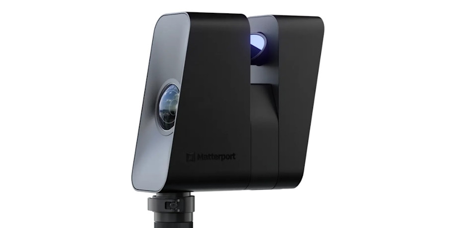
Price: The Pro3 camera bundle starts at $3,995 and also requires a paid Matterport subscription plan. Additional add-ons are available for exports like point clouds, BIM, and CAD files.
Standout features
The Pro3 and Matterport digital twins combine several capabilities that map directly to inspection work:
LiDAR capture: The Pro3 captures depth data up to 100 meters away, with an accuracy range of 20mm at 10m. A standard scan runs in under 20 seconds, shooting high-resolution HDR panoramas indoors and outdoors, including in direct sunlight.
Digital twins: Captured data is processed into a navigable, measurable 3D replica of the whole site, and viewable in a browser so inspectors and reviewers can walk the space and re-check conditions after the visit, instead of returning to site.
Tags, Notes, and Attachments: Pin hazard callouts, text, video, and documents to exact locations, and collaborate with mentions and task management inside the digital twin.
Field Tags: Add tags while actively scanning, offline included, so inspection context is captured live, even when you’re offline.
Automated Measurements and Measuring Tools: Automatically see accurate wall lengths, room dimensions, and object distances calculated from your scan, and remotely pull additional measurements directly from a digital twin whenever required.
Schematic Floor Plans: Order PNG, PDF, and SVG plans to give safety teams a shareable layout to mark hazards, egress routes, and inspection zones.
Side-by-Side views (public beta): Compare two twins simultaneously to track conditions or corrective actions over time.
Export and integration options: Hand off OBJ, XYZ, point cloud, BIM, and CAD files, with connections into Procore, Autodesk, and Revit, so inspection findings hand off cleanly to engineering and contractor teams for structural follow-up.
Capture Services: Teams that would rather skip in-house hardware investment can book certified technicians in hundreds of cities to keep recurring inspections on schedule across distributed or hard-to-staff sites.
Together, these turn a walk-through into an annotated, shareable inspection record.
Strengths
For safety inspection programs, the Matterport platform translates into several concrete advantages:
Reduced hazard exposure: Teams capture once, then inspect the twin virtually, cutting time spent inside operational, elevated, or dangerous areas.
Standardized quality of records: Every location gets documented the same way, which removes the inconsistency between inspectors that plagues photo-and-notes workflows.
Collaboration reach: Stakeholders who were never on site, including corporate EHS and off-site engineers, review the same conditions from any device, with customized Views providing curated information based on the user.
Enterprise readiness: The platform carries SOC 2 Type II, GDPR and CCPA compliance, SSO, role-based permissions, and audit logs.
Reusable resources: Digital twins double as immersive employee training and emergency planning resources, letting new staff walk a hazardous area virtually before they ever set foot in it.
Limitations
The Pro3’s accuracy range of ±20mm at 10m is excellent for facility and hazard documentation, but it isn't survey-grade metrology. For tolerance-critical structural or process engineering work, you'll still want a terrestrial scanner in the millimeter range.
There's also an upfront hardware investment to weigh. Point clouds, BIM, and CAD deliverables all require a Professional plan or higher, so budget for the subscription tier you need alongside the camera.
Best for
Matterport fits teams with repeatable inspections who also want to repurpose the records for other workflows:
EHS and facilities teams running recurring safety inspections across large, multi-level, or multi-site portfolios who need one reusable spatial record per location.
Organizations working to reduce personnel time inside operational, elevated, or hazardous areas.
Safety and risk teams that must produce accurate, shareable documentation for audits, insurers, and incident investigations.
Companies coordinating findings with contractors and engineering partners through Procore, Autodesk, or BIM and CAD handoffs.
2. Insta360 X5: Best 3D scanning tool for rapid visual safety inspections
The Insta360 X5 is a pocket 360 camera, and for safety work its appeal is low friction. When you need visual documentation of a routine walkthrough, the X5 lets you capture a whole area in one continuous pass. You can hand the tool to a shift supervisor who's never touched a scanner and still get usable footage back.
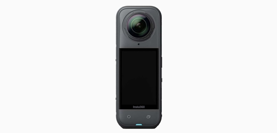
Image source: Insta360
Price: Starts around $549 for the standard camera-only bundle, with accessory bundles running a bit higher. There's no mandatory subscription to shoot and edit in the Insta360 app.
Standout features
The X5 earns its keep in tough field conditions in particular:
Waterproof, rugged build: The body is rugged, waterproof to 49 feet, and able to handle both hot and freezing temperatures, with tough lenses and a built-in wind guard for clearer audio. It holds up during outdoor, wet-area, and rough-site inspections.
In-app stitching and editing: The camera stitches footage in-app, supports flat-lay editing, and exports, turning a walkaround into an inspection report quickly.
Platform pairing: On its own, the X5 produces flat and spherical media, and records 8K 360° video. You can also feed those captures into a compatible digital twin platform like Matterport to create navigable, taggable inspection records.
The result is a fast, cheap way to build a visual trail of routine conditions.
Strengths
The X5's main advantages are practical rather than technical:
Capture speed and portability: It fits in a jacket pocket and documents an area in a single walk, no tripod setups required.
Accessibility for non-specialists: Anyone comfortable with a smartphone can operate it, which widens who on your team can capture.
Cost per unit: At a few hundred dollars, you can equip several sites or crews without a capital request.
For safety inspection programs on harsh sites with a tight budget, the combination is hard to beat.
Limitations
The X5 has no LiDAR depth sensor, which is its defining constraint. Any measurement you try to pull from the imagery is an estimate, so it can't support clearance checks, egress width verification, or similar verification workflows.
Raw 360 files also aren't a structured inspection record on their own. You need a platform to host, tag, and organize them, or you’ll end up with a folder of spherical videos and no way to search or annotate them. On large sites, extended captures can run into battery life and heat management limits before you finish.
Best for
The X5 suits speed-first, budget-conscious visual work:
Daily or pre-shift visual walkarounds where speed outweighs dimensional accuracy.
Small teams starting a documentation program with a limited budget.
Supplementary capture between formal, full-facility inspections.
3. Leica BLK360: Best 3D scanning tool for survey-integrated safety inspections
The Leica BLK360 is a compact terrestrial laser scanner. It fits inspections whose findings flow straight into engineering, structural, or as-built work. When a safety issue you spot needs to be analyzed by an engineer as a point cloud, the BLK360 is a good choice.

Image source: Leica Geosystems
Price: The system costs $26,500, a significant step up from camera-based tools and a reflection of the survey-grade hardware inside. An additional subscription will be required for processing and hosting the model.
Standout features
The BLK360's specs put it firmly in survey territory:
Range: It scans from 0.6 up to 60 meters, covering open industrial spaces and hard-to-reach structures in fewer setups.
Point measurement rate: The LiDAR captures up to 360,000 points per second, capturing dense detail for clearance and structural checks.
Thermal imaging capability: A full-dome scan captures a spherical image and a thermal image alongside the point cloud to help spot heat-related hazards such as overheating equipment.
Accuracy: Ranging accuracy is 4mm at 10 meters and 7mm at 20 meters, with 3D point accuracy of 6mm at 10 meters for tolerance-critical clearance and structural deformation checks.
Point cloud and panoramic output: It exports LGS, RCP, or E57 files for straightforward downstream work, and integrates with Autodesk tools like Civil 3D, AutoCAD, and Revit, feeding structural analysis and engineering handoff after an inspection.
Matterport support: The BLK360 G1 device is compatible with Matterport, so teams can publish scans as navigable digital twins alongside the point cloud deliverables, giving non-technical viewers a way in.
That mix of accurate point clouds and thermal data makes it a suitable tool for engineering-adjacent inspections.
Strengths
Two strengths of the Leica BLK360 stand out for safety teams tied to engineering work, whose inspections routinely feed as-built or structural analysis:
Accuracy-to-portability ratio: It's small enough to hold in one hand yet scans an area 60 meters away, and light enough to mount on a drone. You get survey accuracy without lugging a heavy instrument.
Value of a point cloud: A dimensionally rich point cloud supports structural monitoring, clearance verification, and clean handoff to engineering partners, which flat imagery can't do.
Limitations
Per-scan time is the first tradeoff of the Leica system. A standard-resolution 360-degree scan takes under 50 seconds, but covering a large industrial site means many separate setups, which adds up quickly.
Registration and processing can also mean considerable work. Stitching all those scans together and cleaning the data assumes software skill and time at a desk, not a task a safety manager picks up casually. Raw point clouds are difficult for non-technical stakeholders like plant managers and insurers to interpret without a viewer layer. It's worth deciding up front whether you'll add one, contributing to an already high sticker price.
Best for
The BLK360 suits teams already close to engineering workflows:
Safety teams embedded in engineering or capital projects organizations.
Facilities where inspection findings routinely trigger structural or as-built analysis.
Organizations that already own survey software licenses and staff who can run them.
4. FARO Focus: best 3D scanning tool for complex technical safety inspections
The FARO Focus is a high-end terrestrial laser scanner built for dense, geometrically complex environments like process plants, refineries, and utility sites. On these sites, millimeter tolerances and hundreds of meters of range are real requirements rather than nice-to-haves. When you need to capture a tangle of pipe racks and structural steel with engineering precision, this class of tool can handle it.

Image Source: FARO Technologies
Price: FARO’s pricing isn't listed openly as other tools, but online suppliers suggest the hardware will run well into five figures, varying by range model. Additional FARO software licenses are required to process scans, with modeling add-ons priced separately.
Standout features
The Focus is engineered for demanding technical capture:
Long-range capture: Range extends up to 400 meters, documenting large, open sites like refineries in fewer moves and less time on the ground.
Ranging accuracy: Accuracy up to 2mm for tolerance-sensitive geometry such as pipe clearances and structural steel.
HDR imaging: Preserves detailed color context for hazard identification and reporting.
On-board scan registration: Pre-registration feeds scans directly into the cloud so jobs run more efficiently.
Environmental ratings: The scanner carries IP54 protection for indoor and outdoor use, so it can capture harsh or hazardous process environments safely.
FARO SCENE and Sphere workflows: A full software suite handles processing, registration, and cloud collaboration.
Engineering deliverables: Dense point clouds, deviation analysis, and clash-relevant as-built data for structural and post-incident review.
That's a toolset built for the hardest capture environments in industry.
Strengths
The Focus earns its price in two scenarios:
Congested industrial geometry: Pipe racks, structural steel, and confined mechanical spaces are exactly where its density and long range shine, capturing detail cheaper tools miss.
Forensic value: Its high-fidelity capture supports post-incident reconstruction and expert analysis, where defensible, high-precision data can carry legal weight.
For complex process environments and investigations, few tools match it.
Limitations
Total cost of ownership is the headline constraint. Between hardware, software licenses, training, and processing time, the Focus represents a serious ongoing commitment.
It also demands a specialist operator. This isn't a tool a safety manager picks up between audits. It assumes a trained scanning technician. And the data volume is heavy, so organizations without existing point cloud infrastructure face a real IT and storage burden to support it.
Best for
The Focus fits organizations with the geometry and the expertise to justify it:
Oil and gas, chemical, and utilities sites with dense process equipment.
Forensic and post-incident investigations requiring defensible metrology.
Organizations with in-house survey or scanning specialists.
5. Apple iPhone and iPad LiDAR: best 3D scanning tool for on-the-go safety inspections
LiDAR-equipped iPhones and iPads from Apple are portable devices that many inspectors already have in their pocket. There’s no need for a tripod or setup, just pull out the phone and scan the thing you found. Pro and Pro Max iPhones, rather than standard models, carry a built-in LiDAR scanner.

Image Source: Apple
Price: An iPhone Pro starts around $999. For technicians who already carry a Pro phone professionally, the marginal cost for LiDAR specifically is zero. Capture apps range from free to about $20 a month.
Standout features
The value here is depth capture in a device you already own:
Range: Recent Pro models give reliable distance measurements up to 10 meters, suited to single rooms, electrical closets, and confined equipment areas.
Integration with capture apps: Third-party apps convert the sensor's depth data into 3D models an inspector can attach to a hazard report
Hand-held capture: You scan by moving the phone slowly around a space, no fixed setup required, so inspectors can document findings on the spot.
The tool is most practical for speed of response. A technician can document an unexpected hazard on the spot and reference it alongside the site's primary inspection method.
Strengths
The phone's advantages come down to availability and ease:
Zero incremental hardware cost: The device is already in the field, so there's nothing new to buy and near-universal access across the team.
Minimal learning curve: Inspectors who resist new equipment will use a phone they already know, which drives adoption.
Fits awkward spaces: In confined or cramped areas where a tripod-mounted scanner won't fit, a handheld phone gets the capture.
For quick, localized documentation, nothing removes friction like the tool already in hand.
Limitations
The short range is the main ceiling. Beyond a 3 to 4-meter distance, scans are less reliable, the signal weakens and point density drops.
Image quality and lighting sensitivity are another issue, so results suffer in poor light. And because errors accumulate as you move, scan-time and drift limits make full-facility capture impractical. The phone is a spot tool, not a site tool.
Best for
Mobile LiDAR fits quick, contained documentation:
Spot documentation of newly identified hazards between scheduled inspections.
Single rooms, electrical closets, and confined equipment areas.
Teams piloting 3D documentation before committing to dedicated hardware.
Apple's specified maximum range is roughly 5 meters indoors. In practical use, the effective range for a dimensionally reliable scan is closer to 3 to 4 meters. Beyond that, the return signal weakens and noise takes over.
Match the 3D scanner to your safety inspection program
To choose the right 3D scanner for your facility inspection program, consider what you need to accomplish. A few concrete rules cover most situations:
Use survey-grade hardware when tolerances drive an engineering or legal decision. Structural movement, egress width disputes, and pipe rack clearances all demand the millimeter accuracy of a Leica BLK360 or FARO Focus, because the number itself is what's at stake.
Use a full-context scanner when the goal is documenting conditions. When you're recording the state of a facility, tracking corrective actions, and briefing stakeholders, photorealistic context with reliable measurement beats raw precision.
Use mobile devices for quick spot checks. For a single room or an unplanned finding, the phone in your pocket closes the gap between a photo and a spatial record.
Most EHS programs live in that middle category, where Matterport’s Pro3 and digital twin platform deliver complex site replicas fast for a reusable record the whole organization can work from.
Get in touch with our team

